GIS4AG
Canadian Prairies Legal Subdivision (LSD) to Map Coordinates Databases
Canadian Prairies Legal Subdivision (LSD) to Map Coordinates Databases
Couldn't load pickup availability
What is this product?
Please note that these are Legal Subdivision (LSD) data, NOT our Legal Description (Section/Quarter Section) database.
Legal subdivisions are 40ac parcels whereby each quarter section is further divided into 4 parcels. Legal subdivision references are typically used in the oil and gas industry, and not commonly used in agriculture or general utilities. These data were created by dividing quarter section polygon boundaries into a further 4 quarters, and the coordinate data refer to the centroid of these subdivision parcels.
In response to numerous requests, we have created and made available geocoding databases that allow the latitude and longitude of legal land locations to be generated. If you are building an application where you need to convert Legal Subdivision – Section – Township – Range – Meridian into Lat/Lon coordinates then you will definitely find this useful and valuable.
We have compiled CSV tables that contain the LSD land location descriptions and lat/lon map coordinates for each point, ready for deployment in your application
What will I receive?
All data are supplied in Access Database and CSV text format and available for immediate download after purchase
Each database contains the coordinates, in decimal degrees, of every subdivision in the respective province. The data are provided in a variety of column configurations. For maximum compatibility with a variety of end users, the data are provided in .csv format and Access Database (you'll receive both formats). Sample data are provided for you to test before purchasing, once you are satisfied the data are suited to your purpose, and you’ve read the EULA to ensure the data may be used for your project, you can purchase and download the data from the Store.
You'll receive CSV files and Access Databases formatted exactly the same as the sample files (downloadable from links below) for the following Provinces:
- Manitoba
- Saskatchewan
- Alberta
Immediately after you complete the checkout process, your files will be available for download from either the checkout page or from the My Account area.
Please download the samples and confirm this is what you require prior to purchasing as we can't offer refunds on downloadable products.
Who Is This Product For?
Anyone that is developing an application where you need to geo-code legal subdivisions (LSDs) into map coordinates.
What's Included in the Data?
We went to great lengths to compile data that fits the needs of a wide variety of applications. The resulting databases are the results of hundreds of hours of GIS processing to generate them!
Data you'll receive:
- Centroid Coordinates for every legal subdivision
- Various data columns to fit with your query formats
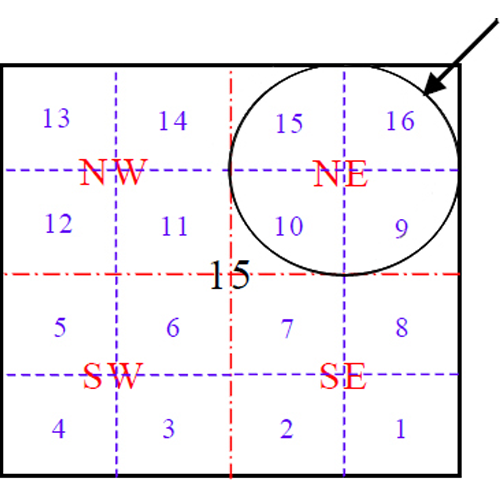
Understanding the Naming Conventions Used
Legal Subdivisions divide each square mile section into 16 segments, and use a numbering convention between 1 and 16 to define the location of the subdivision within the section:

Download Sample Data
What It Doesn't Do
Please download and verify that the sample data are suitable for your needs as the paid data use the same format. LSD centroid coordinates were computed from publicly available quarter section polygon data, and while we believe they are extremely accurate, these data should not be used to identify exact LSD centroids or as a basis to define legal boundaries.
What Can I Do With The Data?
Here's the EULA.
Basically, you can use it in any applications where the databases won't be available to the end user in their original form. And you can't re-sell the data.