Advanced Technology for Modern Agriculture
Comprehensive solutions for management zone creation, farm drainage design and planning, elevation data, weather planning, mapping tools, and professional training. Built by leading precision ag and technology experts.

TerraZoner™
The Simplest Way to Create Professional Management Zones
Two zone engines with terrain intelligence. Export to any software. No ecosystem required.

Drain-IQ™
Your Entire Farm's Drainage Mapped — From $999
Flow paths, ponding, wetness index, and design tools. Professional drainage intelligence you control.

Geo-Surface Pro™
Professional Drainage Design. Simplified.
The fastest way from LiDAR to drainage. Design tile and surface systems in your browser.
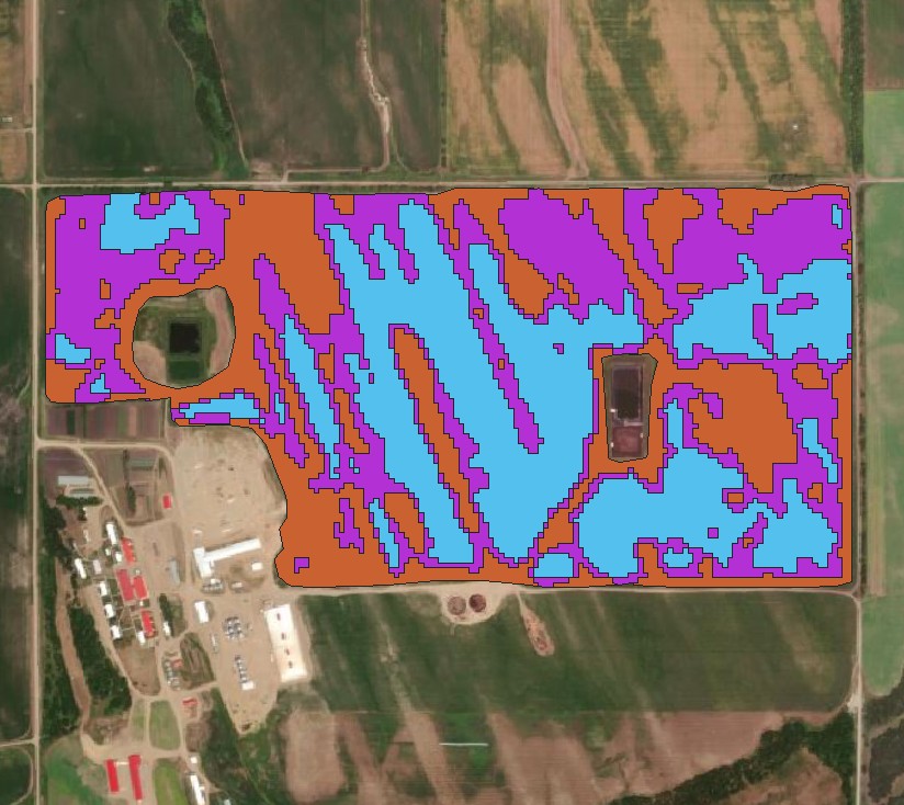
Four Zone Approaches.
One Subscription.
From satellite-based productivity zones to terrain-only classification — TerraZoner puts you in control. Pick the right approach for every field. Tweak, iterate, export. As many times as it takes.
The Problem With Traditional Satellite Zones
A dry hilltop and a wet depression both show up as "low-producing" — lumped into the same zone, even though they need completely different treatment. And if you outsource zone creation, you wait days for a map you can't adjust. TerraZoner separates what satellite alone can't, and lets you run it yourself — no middleman, no waiting.
Satellite-based productivity zones from years of peak-season imagery. The foundation for ~75% of VR acres.
Reclassifies low-producing zones using LiDAR terrain — splitting droughty hilltops from wet depressions.
Full productivity-by-wetness classification. Up to nine distinct zone classes for advanced VRT prescriptions.
Terrain-only zones from LiDAR — no satellite needed. Best for VR seeding, new land, and fields without crop history.
Stop Waiting. Start Zoning.
One subscription. Four zone approaches. Every field you manage.
30-day satisfaction guarantee — if it doesn't deliver, we make it right or refund you
Drain-IQ
Stop guessing where water goes. Get your entire farm's elevation and drainage patterns mapped from high-resolution LiDAR — see flow paths, find problem spots, and plan improvements with confidence. Your custom portal is ready in days, accessible from any device.
Your Entire Farm. One Price. No Surprises.
Compare that to a drainage contractor's survey at $15-25/acre. For a 640-acre section, you'd pay $9,600-$16,000. With Drain-IQ, you get your entire operation mapped — every quarter, every field — for a fraction of the cost.
Your Whole Operation
Every field, every quarter — one flat rate covers it all.
Built Just For You
Your own branded portal with your fields, your data, your name.
In the Field or the Office
Pull it up on your phone while standing in the field. No app to install.
See What You've Been Missing
-
Know Where Every Drop Goes
Flow paths reveal the invisible drainage network across your land. Finally understand why that corner always floods.
-
Check Elevations Instantly
Tap anywhere to see exact elevation. Planning a tile run? Know the grade before you call the contractor.
-
Find Every Low Spot
Depression mapping shows where water collects — even in a dry year. Stop discovering problem areas the hard way.
-
Plan Before You Dig
Draw drainage routes, check grades, export PDFs for contractors. Make informed decisions before spending a dime.
-
Always Current
Multi-year plans include free updates when new LiDAR is released. Your maps stay up to date.


Know Your Land Like Never Before
See exactly how water moves across your farm. Identify drainage opportunities before next spring. Check coverage for your area and explore the interactive demo.
Geo-Surface Drain Pro
A complete professional platform for designing surface and subsurface drainage systems from LiDAR. Built for people who need accurate, efficient, and repeatable designs without expensive desktop software. Try it free at geo-surface.com — explore high-resolution LiDAR terrain and check elevations instantly. Upgrade to Pro when you're ready to design complete surface and tile drainage systems.
Professional Drainage Design Tools
Full-featured drainage design platform. No expensive desktop software required.
Browser-Based
Works anywhere. No installation required.
Fast & Accurate
LiDAR-based analysis in seconds.
Complete Toolkit
Everything from analysis to export.
Complete Design Platform
-
Automatic LiDAR Download
Download high-resolution elevation data automatically where available, or import your own DEMs.
-
Advanced Terrain Analysis
Generate flow paths, depressions, ponding areas, and wetness potential layers in seconds.
-
Design & Optimization
Draw, connect, and optimize mains, submains, and laterals with automated validation.
-
Best-Fit Grade Analysis
Maintain slope accuracy and minimize cut/fill with intelligent grade optimization.
-
Export Everything
Download GIS shapefiles, PDF maps, detailed reports, and cost summaries — perfect for planning and contractor coordination.

Ready to Design Professional Drainage Systems?
Explore the free viewer, check elevations, and see what Pro can do for your drainage designs.
LiDAR Extractor
Get high-resolution elevation data without the complexity. Whether you're designing drainage for a single field, planning land leveling across a farm, or analyzing terrain for an entire watershed — extract exactly what you need in minutes, not hours. No expensive desktop GIS required.
-
Select & Define
Choose US (3DEP) or Canada (HRDEM), then draw your boundary or upload a shapefile — from single fields to entire regions.
-
Choose Resolution
1m for precision drainage work, up to 500m for regional analysis. Intelligent resampling keeps file sizes manageable.
-
Preview in 3D
Explore hillshade and elevation overlays. Verify coverage and quality before downloading.
-
Export Your Way
GeoTIFF, Shapefile, CSV, KML, ASCII Grid, Surfer GRD, or AGS — in meters or feet, UTM auto-detected.

Survey-Grade LiDAR Data in Minutes
Drainage design, land leveling, terrain analysis, watershed planning — get the elevation data you need without fighting complex software.
Online Courses
Practical, hands-on courses taught by industry experts. Learn precision agriculture techniques, drainage design principles, and advanced GIS workflows at your own pace.
Tile Drainage Design Principles
Professional Drainage System Design
Comprehensive training on tile drainage design principles for agricultural applications. Learn proven methods for designing effective subsurface drainage systems that improve field productivity and profitability.
- Design Fundamentals - Core principles of tile drainage systems
- Practical Methods - Real-world design techniques and workflows
- Professional Skills - Industry-standard drainage design practices
Management Zones & VR Prescriptions
Using Free Satellite Data and QGIS Software
Learn to create professional multi-year management zones and variable rate prescriptions using free satellite data and open-source QGIS. Complete this practical course in under a day and gain the skills to create unlimited custom zones for your fields.
- Complete in One Day - Fast-paced, practical instruction
- Free Tools - Learn QGIS and access free satellite data
- Unlimited Fields - Apply your skills to any number of fields
Tools & Data
Custom-built tools and premium data layers designed for agricultural professionals. From quarter section navigation to detailed soil mapping and LiDAR processing—everything you need in one place.
Google Earth Overlays
Find Land Boundaries Instantly in Google Earth!
Ready-to-use KMZ files that add accurate quarter section boundaries directly onto Google Earth for Manitoba, Saskatchewan, and Alberta. Download, double-click, and start exploring land boundaries in seconds.
- Instant Setup - Works immediately in Google Earth
- Complete Coverage - All RMs/counties plus Manitoba River Lots
- Built-in Tools - Measure and analyze using Google Earth Pro
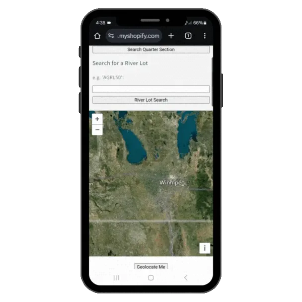
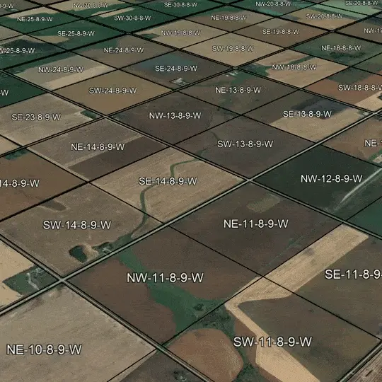
Prairie Quarter Locators
Find any quarter section in MB SK AB
Quickly lookup any quarter section on the Canadian Prairies using any device—no app needed. Navigate to legal land locations with Google Maps and geolocate your position to see which quarter section you're on.
- Instant Lookup - Find any quarter section by legal land location
- Google Maps Navigation - Direct routing to quarter sections
- GPS Geolocation - See your current quarter section position
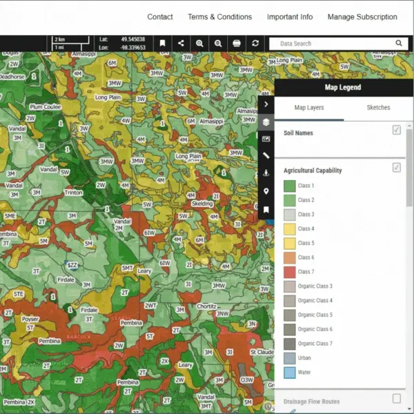
Manitoba Soil Mapper
Unlimited Access to Manitoba's Most Advanced Soil Mapping!
Exclusive access to Manitoba's most detailed interactive soils map portal for farmers, crop consultants, investors, and assessors. Includes Soils 101 lessons with knowledge checks to learn soil science fundamentals.
- Detailed Soil Data - Interactive portal with comprehensive soil mapping
- Soils 101 Course - Educational lessons with knowledge checks
- Smart Decisions - Insights for land buying, crop planning, and valuations
GIS Data
Premium Agricultural Data Layers
Premium agricultural and geospatial data layers designed for precision farming, land management, and agricultural analysis. Access curated datasets ready for immediate use in your GIS software.
- Premium Datasets - Curated agricultural data layers
- Ready to Use - Compatible with standard GIS software
- Professional Quality - Accurate, up-to-date information
Precision Agriculture Made Practical
Making geospatial data and precision agriculture tools accessible, actionable, and effective for farmers, agronomists, consultants, and ag tech professionals since 2008.
Meet Simon Knutson
Founder & Lead Developer
For nearly two decades, I've been at the forefront of precision agriculture, GIS, and ag tech innovation. Since founding GIS4Ag in 2008 and co-founding Northern Plains Drainage Systems in 2012, I've developed industry-leading tools like Ditch Assist™, spent 4 years teaching precision agriculture and agriculture technology at Olds College, consulted on and led product and service development initiatives for diverse organizations across the ag tech and precision agriculture sectors, and helped farmers, municipalities, and businesses make smarter, data-driven decisions.
Haven't heard of me before? That's fine! Unlike many in this space, I focus on practical, results-oriented solutions—not hype or self-promotion. My work speaks through the tools farmers use daily, the students who've built successful careers in precision ag, and the real-world problems we solve together.
Whether you're looking for professional mapping tools (PowerZoner, Drain-IQ, Geo-Surface Pro), hands-on training (QGIS courses, precision ag fundamentals), or ready-to-use data products (Google Earth overlays, LiDAR processing)—GIS4Ag provides the platform, expertise, and support to help you work smarter and achieve better outcomes.