Easily Identify Quarter Sections in Google Earth
What Is This Product?
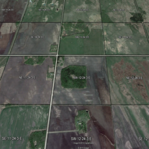
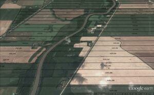
Unlock a powerful mapping tool with our Google Earth quarter section overlays. These custom .KMZ files seamlessly add quarter section boundaries to Google Earth, allowing you to easily locate, measure, and analyze land parcels across Manitoba.
- ✅ Includes ALL Municipalities in Manitoba (one KMZ file per Municipality)
- ✅ Delivered as a downloadable ZIP file
Google Earth Pro is now FREE! It used to cost $400/year—if you haven’t installed it yet, grab it now! It lets you measure areas, export high-resolution imagery, import shapefiles, and more.
Why You Need These Overlays
- Find any quarter section instantly – Use Ctrl+F to search legal descriptions.
- View detailed land boundaries directly over Google Earth imagery.
- Measure areas & distances with built-in tools.
- Print high-resolution maps for professional or personal use.
- Works for real estate, land assessment, utilities, farming, and more.
What You’ll Get
As soon as you complete checkout, you’ll get instant access to download your files from the checkout page or your account.
📂 Inside the ZIP file:
✔ Separate .KMZ file for each RM or county
✔ Just double-click to add it to Google Earth
✔ Organized for easy access and navigation
✅ Try Before You Buy – Download free samples to see exactly what you’re getting:
📍 Manitoba Sample – RM of Grey
⚠️ No Refunds on Digital Downloads – Be sure to check the samples before purchasing.
Who Is This For?
- Realtors needing quick land boundary insights for rural properties
- Farmers & Landowners looking to measure, analyze, or plan their fields
- Utility & Infrastructure Planners needing parcel maps for projects
- Assessors & Insurance Professionals working on property evaluations
- RMs & Counties needing better visualization of their land assets
How It Works
1️⃣ Download & Install Google Earth Pro (PC recommended)
2️⃣ Extract the ZIP File to your computer
3️⃣ Double-click a .KMZ file (or drag it into Google Earth)
4️⃣ Instantly see quarter section boundaries as an overlay
💡 Pro Tip: Displaying multiple RMs at once may slow down older computers.
Compatibility & Important Notes
✅ Works on Windows PCs & possibly Mac
⚠️ Google Earth Mobile App – May not display overlays correctly
⚠️ Imagery Accuracy – Google Earth imagery isn’t always 100% accurate, so expect small positional shifts
⚠️ Not a Legal Survey – This product is for reference and visualization only.
Get Instant Access Now
Don’t waste time hunting for land boundaries—download your quarter section overlays today and start using them in Google Earth immediately!